
Glacier Icefall Nearly 2,000 Meters from Langtang North Triggered Devastating Flood
Summary
Prepared and Edited Using AI Assistance.
- Researcher Santosh Nepal reported that a massive icefall and landslide from the northern slope of Langtang Mountain over the Lhende River in Rasuwa caused the devastating flood.
- Nepal clarified that the Rasuwa flood was not caused by a glacial lake outburst but rather by glacier ice falling approximately 3,000 meters down from an altitude of around 5,000 to 5,500 meters.
- He emphasized the need to enhance early warning systems by incorporating remote sensing, AI technology, and international information exchange, highlighting increased risks from the climate crisis.
Last Wednesday morning, a catastrophic flood originating from the upper reaches of the Lhende River near the Nepal-China border caused significant human and property damage from Rasuwa to Muglin. The flood was triggered after a massive landslide, including a large icefall, descended from the northern slope of Langtang Mountain.
Santosh Nepal, a Ph.D. researcher in water resources and climate change, indicated that the energy released from an icefall that fell approximately two thousand meters contributed to the destructive flood. OnlineKhabar journalist Krishna Gyawali spoke to Nepal about the causes of the Langtang landslide and the resulting Rasuwa flood. Below is an edited excerpt of the conversation:
The flood on the Lhende River at the Nepal-China border devastated many areas in Nepal. What could be the reason for such a sudden and massive flood?
The flood in Rasuwa was extremely destructive. There has been no precedent in Nepal’s history of such a sudden and powerful flash flood.
Various factors can cause such devastating floods in hilly regions. Yesterday, after receiving some satellite images, we identified the reason behind the landslide.
Initially, many experts speculated that a glacial lake outburst or a similar event caused the large volume of water. Why has the assessment changed?
There are numerous glacial lakes in the mountainous regions, so after a major flood, the first suspicion naturally falls on these lakes. Since the Bhote Koshi region also hosts glacial lakes, it was normal for experts to suspect them.
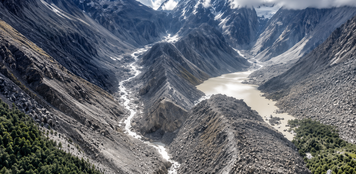
However, Planet Labs satellite images disproved this assumption. They revealed a landslide had occurred on the northern part of Langtang Mountain at an elevation of approximately 5,000 to 5,500 meters.
The satellite photos show a significant landslide involving glacier ice and snow that fell downhill. Preliminary estimates indicate that the rock and ice mass, including large ice boulders, fell nearly two thousand meters directly downwards.
Such a massive icefall releases significant energy, which likely accelerated glacier melting. Details about how long the Lhende River was dammed, how much water accumulated, and the mechanism of its release will become clearer in a few days.
You mentioned ‘glacier ice fall’ as the main cause of the flood. Could you explain why?
Snow accumulates over mountain rocks for a long time, gradually transforming into glacial ice, forming glaciers that slowly move downward each year, shedding parts of themselves along the way.
Have such large icefalls and subsequent floods happened before?
Previously, such disasters were relatively normal occurrences. However, combined hazards are now more frequent — including heavy rainfall, landslides, and river breaches causing floods.
Similar incidents occurred in 2013 in Uttarakhand, India, and in 2021 in the Melamchi area of Nepal. The recent Rasuwa flood closely resembles the ‘Chamoli flood’ in India caused by a glacier-rock collapse.
The glacier and ice-rock collapse from the Nanda Devi mountain range triggered massive flood damage. The Rasuwa event is comparable to the Chamoli flood.
Last year in Ashad, there was also flooding in the Lhende River. How comparable are the two events?
The recent flood was a glacier ice fall and landslide event, unlike the previous year’s glacial lake outburst flood (GLOF), which typically happens when small water bodies formed by melting ice in summer break suddenly.
The current flood spread an unusually large volume of water rapidly. What do experts say about such a huge water volume?
The water volume is indeed extremely large and surprising even to us. Investigations are ongoing, and forthcoming satellite data will provide further clarity.
Seismic tremors were recorded in the Langtang area of Rasuwa at the time the flood began. Do you think the tremors triggered the landslide, or were they caused by it?
After a large mass of ice and rock fell, a ground shock occurred at 9:38 am, detected as a tremor. Although similar to an earthquake, its characteristics can differ in magnitude.
Was the energy produced by the glacier falling nearly 3,000 meters from 5,000 meters altitude sufficient alone to cause the flood, or was another event involved?
We cannot confirm until the investigation concludes. However, a large icefall mixes with soil, stones, and water during descent, becoming a destructive debris flow that adds to the damage.
If the Lhende River was dammed by this landslide, shouldn’t hydrological data show decreased water levels downstream?
Sometimes the river flow stops completely when dammed, but reports indicate that measuring instruments downstream might have been swept away by the flood.

Experts initially speculated with limited data, but the satellite data now mostly confirms the icefall hypothesis. How reliable is the analysis based on satellite imagery?
Satellite images are a primary source for our understanding. Though monsoon clouds reduce clarity at times, weather clears provide detailed views.
In 2021, large chunks of glacier and rock fell from the Nanda Devi range causing massive destruction. The Rasuwa flood resembles the Chamoli flood in India.
For thorough details, site visits are necessary, but suitable conditions for onsite research are still awaited. Current analyses are based on limited data.
The released energy from melting ice is said to accelerate glacier melting. What is the difference between ice-mixed landslide and a regular landslide?
When a heavy mass falls due to gravity, it produces energy causing destruction. Similar calculations were made for the Chamoli flood.
Ice-mixed landslides melt faster due to temperature differences. When ice lands in water, which is warmer than ice, it melts more quickly.
At first, it was believed a glacial lake outburst occurred in Tibet, but this was later disproved. Does this still imply that hazardous glacial lakes remain a serious threat?
The International Centre for Integrated Mountain Development (ICIMOD) has identified 27 high-risk glacial lakes in Nepal. These lakes have potential for outbursts but are not expected to burst imminently.
It is essential to prepare and work on risk mitigation without spreading rumors.
If heavy rainfall was not the cause this year or last, what primarily increases the risk?
There was no significant heavy rainfall; only light rain might have occurred. Climate change has heightened risks.
Flood series of such destructive magnitude – what is the primary cause?
Nepal’s mountainous regions are vulnerable to sudden and intense monsoon rains. Climate change has increased these risks.
Rapid temperature rises in mountains weaken rocks and increase landslide danger.
Post the Melamchi flood, the climate crisis became evident, showing the need to prepare for diverse disaster types.

Is temperature rise the main factor behind increasing disasters in mountainous areas, or are there others?
Climate change is the primary driver in both the frequency and scale of disasters. Additionally, many settlements and infrastructures are already located in high-risk zones. Disaster incidents are rising.
Governments and communities need to focus on how to manage risks associated with such infrastructures.
Modern disasters seem different and more intense than those historically recorded. What accounts for this change?
Disasters are now manifesting in novel ways. Structural and policy preparedness remain insufficient and improvements are urgently needed.
How best can future risks be mitigated? Through improved early warning systems, international cooperation, or relocations?
Early warning systems require enhancements via remote sensing, AI technology, and cross-border information exchange. Dialogue with China is imperative.
New infrastructure should incorporate risk-based design principles. Long-term policies must reflect risks posed by climate change.